Overview
The impressive sink of the Nant Cadlan stream in a massive shakehole marks the location of Ogof Fawr, the original route into the cave followed the water down at the base of the cliffs of steeply dipping limestone. A new safer entrance on dry ground at the back of the shakehole was dug to provide a dry and more stable route into the cave after it had been discovered.Length 1300m +
Altitude 326m
Grid SN 98550 09610
History
As a large stream disappeared into the ground here, this site has received the attention of digging teams over many years. Unfortunately the severe winter floods washed rock in to fill the passage cleared by successive digging teams. Since 1969 digging teams from Westminster SG, Croydon Caving Club, Cwmbram Caving Club had all made significant digging efforts at the site, but all thwarted by the significant amount of rock moved down the stream bed to fill their efforts during the winter floods. In 2007 a new effort was made led by Tony Donovan, Paul Quill and Roy Morgan which in 2008 broke through the unstable entrance sink to intersect chambers and cave passage beyond.
Location
From Penderyn take the Cwm Cadlan Road from the junction at the Lamb Hotel. The road should be followed up onto the open moorland until a point is reached where a large cairn located between two large shakeholes is seen 50m from the road. A parking area is located beside the road at this point from where you can head out towards the cave. By heading 1.4km due south, first over two rises, you will reach the valley that contains Nant Cadlan that flows to the shakehole and sink of Ogof Fawr. The dry entrance is in the base of the cliff at the back of the shakehole.Sychryd and Hepste Google map showing the location of Ogof Fawr and other caves in the area.
Location map - click marker to show entrance photo
Access
No known access restrictions.The cave is very near a National Grid gas storage facility so security is very tight if approached from the forestry to the South East.
Description
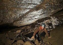
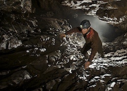
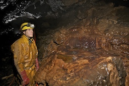
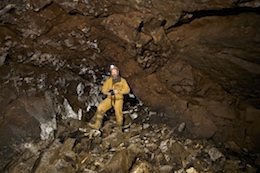
Ogof Fawr was discovered in 2008, having being entered by the diggers after a concerted period of excavation. The site has been long known as a large stream sinks at this site and in view of the potential was named Ogof Fawr (large cave) another small site lower down the valley was called Ogof Fechan (little cave). The irony was that after prolonged digging very little cave was found at Fawr, but Fechan yielded a sizeable stream cave. This cave is formed in steeply dipping beds of limestone and is out of character with most caves in South Wales. In many ways it is similar to Ogof Fechan as the cave is extremely flood prone and most passages are covered in a thin film of mud making the cave feel very oppressive. It cannot be understated how at risk of flood this cave is, with debris found up to 2m above the cave sink after heavy rain. In wet weather the cave completely floods in large sections, this is a cave to avoid in unsettled weather.
The stream sinks in a cliff face in a very large depression, flooding causes the original entrance route through boulders to rearrange regularly, a new drier entrance has been engineered near the cliff face at the back of the depression. A descending passage following the dipping beds of limestone drops you a scaffolded shaft that leads to a further crawl (best tackled feet first) and climb down in lower bedding planes. This finally drops via a short climb down into the top of a chamber - Jones's Locker, in which, close by on the right hand wall by a large boulder is a rope climb down. From the bottom of the rope climb, low down you find a small passage leading off on the right. A scramble down and to the right over loose rocks and sand brings you into a second chamber. In this second chamber the top section is covered by large slabs of rock that have fallen from the roof. These slabs slope downwards to the passage beyond, the best route to progress is to traverse across the slabs to descend near the right hand wall. This steeply descending passage is then followed to meet the water further down and continues to a junction with a large flat topped boulder in the centre. Ahead the water descends a narrow rift to enter a large steeply descending chamber - Mamma Goo's Realm. The water sinks in the boulders at the top of the chamber, at the bottom end of the chamber a climb down through mud covered boulders (ladder needed) leads back to the stream which quickly disappears into a boulder choke. In wet weather water backs up here very badly, the whole chamber filling up with water, foam can be found over the flat topped boulder back at the junction.
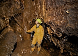
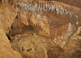
From the junction a passage leads off to the right and continues for a long distance as a linear passage cutting across the dip of the rock. The whole passage is covered in a thin film of mud and it is clear from this and damage to the conservation tapes that much of this passage floods in wet weather. Following the passage to the right of Mamma Goo's Realm leads quickly to a short ascent up clean rock to reach a junction. To the left leads to a section of passage in clean washed limestone that ends as a choke close to Mamma Goo's Realm. To the right the passage soon reaches a low rock bridge - Clapper Bridge. This has short sections of passage leading off at both ends of it. The passage now heads off at stooping height - The Orange Blossom Trail and passes some calcite formations at a small shower inlet in the roof. Beyond the passage contains some static water in the lower side, the first section can be avoided, but a low arch forces entry into the second pool. Here you reach Formation Junction where tapes and a handline guide you through and over a calcite flow. A 4m climb up on the opposite side of this corner leads into Hell's Delight a tight rift with loose boulders, that quickly ends. From Formation Junction the route continues as a fine phreatic passage with a sandy floor to pass below the impressive rock arch - The Penang Bridge. A steep ascent immediately after it leads into an awkward section of passage - The Trudge, where the route is stooping while passing over boulders. Towards the end there is a squeeze through rocks that leads on to the right hand side of the passage where slot behind boulders leads to a drop down into an area of fault breakdown. This is a complex area with several short sections of passage heading upwards, but the way on is generally to go ahead and follow climbs down found on the right hand wall. The last of these descents - The Trombone Squeeze (now enlarged) drops down to a low crawl that starts off wet and then ascends with a squeeze over a large boulder to lead into slightly larger passage. This passes a large quartz vein in the rock and soon arrives a a short climb down into larger passage. Two low passages on the left soon choke while ahead some old dried and decaying gour pools are seen. A low arch on the right above these gours gives entry to a low sandy crawl that enters a wide and ascending fossil passage, where passage height is gained as you progress. At a point where you can stand is a passage on the right, while ahead the sound of a small inlet indicates a small pot that becomes too tight. The passage then ends at a sandy dig. The passage on the right can be followed as comfortable crawls and stoops to reach a fine dried crystal pool on a corner. Following around the corner leads to an ascending phreatic tube that you can crawl up to lead to the top of a climb down. A knotted rope assists the 4m climb down that is split into two sections to arrive in the top of a steeply descending chamber. The chamber regularly floods as can be seen from the mud covering on all the walls, floor and formations.
Back in the main passage the route ahead splits into a lower and higher oxbow that quickly rejoin in a section of larger passage. This reduces in height until a boulder choke is reached where the route towards the right, under a boulder and down through a hole below. The route now is a little harder going being generally crawling and stooping over boulders passing first a passage on the left that quickly chokes and then reaching a junction where a large oxbow is located. The lower route leads via a phreatic bedding crawl, while the higher route continues over boulders as previously. These both rejoin after 30m to emerge in larger passage to lead onto a complex area of passages that mark the current end of the cave. The passage swings left around a corner where a hole down through boulders leads to the Passion Pit - and void below the passage and a lower section of passages. Following the main passage ahead leads to an ascent under boulders to reach a fork in the passage. To the left a wide section of passage is reached, that chokes, while to the right the passage descends to the sound of a small stream inlet. Following the water source, a rift can be followed that ascends until a chamber is reached at the base of an aven. A rope hangs from the aven while on an opposite wall a passage can be entered to gain a 30m long wet crawl that ends too tight. Back at the entrance to the wet rift a second low passage to the left can be followed as a low wide crawl for 15m to reach a sandy floored chamber - Oxwich Bay. To the right this slopes upwards to reach a choke while following the lower end of the chamber a low crawl can be followed. This leads on to 60m of passage, but was choked after 15m when visited in 2014.
Tackle
No tackle required
References
Cambrian Cave Registry for Ogof FawrUK Caving Wiki Entry for Ogof Fawr
Descent 201 Article p20-22 So near and yet so Fawr | Tony Donovan
Warnings
This whole cave is very unstable and extremely flood prone - treat with due care.
Disclaimer
The photographs and information of this page has been provided to help cavers planning trips. Caving can be a dangerous activity, if you are interested in exploring caves please join a caving club so you can enjoy a safe introduction to this sport. Local caving clubs are listed on the links page or you can visit the 'New To Caving' website for more options.If you feel that any of the information is incorrect or should be updated please contact us.


